Missing information?
Do you have any additional information you would like to share about a soldier?
Submit- Full
name
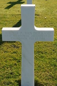
VAN DER KAMP, Walter P - Date of
birth
29 November 1912 -
Age
31 -
Place of birth
Santa Clara, Santa Clara County, California -
Hometown
San Mateo, San Mateo County, California
Personal info
Military service
- Service
number
T-185448 -
Rank
Flight Officer -
Function
Pilot -
Unit
722nd Bombardment Squadron,
450th Bombardment Group, Heavy
-
Awards
Purple Heart,
Air Medal with Oak Leaf Cluster
Death
-
Status
Killed in Action - Date of
death
22 February 1944 - Place of
death
Near Regensburg, Germany
Grave
-
Cemetery
American War Cemetery Ardennes
| Plot | Row | Grave |
|---|---|---|
| A | 42 | 34 |
Immediate family
-
Members
Martin C. Van Der Kamp (father)
Frieda M. Van Der Kamp (mother)
Lawrence Van Der Kamp (brother)
Jack F. Van Der Kamp (brother)
Anna M. Van Der Kamp (sister)
Katherine F. Van Der Kamp (sister)
Jean Van Der Kamp (wife)
Martin Van Der Kamp (son)
Plane data
- Serial
number
42-7714 -
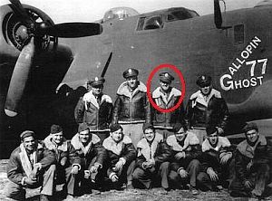
Data
Type: B-24H
Nickname: Gallopin Ghost
Destination: Regensburg, Germany
MACR: 2694
More information
F/O Walter P. Van Der Kamp worked as a dairyman.He enlisted in the Royal Canadian Air Force because he was too old to enter the Air Forces in this country. At the time of his transfer he was a sergeant but on 23 December 1942, he was appointed a flight officer with 850 hours of flying credit.
Statement of S/Sgt Theodore H. Erickson:
'In reference to Flight Officer Vanderkamp's ship which was on the mission to Regensburg, Germany, 22 February 1944, the first thing that I noticed was fighters attacking it and the ship lost altitude and then regained control. It then appeared to be turning back with smoke pouting out. When I last saw the ship, one enemy fighter was hovering over it. I saw no chutes open as the plane disappeared into the undercast, however it was under control even though it was losing altitude fast. The time was approximately 1305, the altitude was approximately 22,000 feet. The coordinates as called by the navigator was 48°20'N; 12°50'E.'
Source of information: Peter Schouteten, www.abmc.gov, National Archives, www.wwiimemorial.com, CWGC/ABMC, www.findagrave.com, www.ancestry.com - 1930 Census, www.fold3.com - MACR 2694, www.450thbg.com
Photo source: Mark Wood, son of Adam E. Wood / www.450thbg.com, Peter Schouteten, El Paso Herald-Post - 21 July 1943